'
'
 |
 |
|
 |


 |
||
 |
||
 |
||
 |

 |
|
| Revised March 7, 2024 |
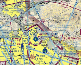
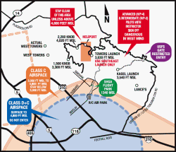
Airspace Maps
|
||||||||
 |
||
FLIGHT PARK INFO | WEATHER | NEWS & EVENTS | PILOT FORUM | CONTACT | MEMBER LOGIN Copyright Sylmar Hang Gliding Association, Inc. TERMS OF USE. Site donated by: Sonic Media |
||
|
'
'
'
|
|||||||||||||||||||||||||||||
|
|
||||||||||||||||||||||||||||
|
|||||||||||||||||||||||||||||